E6: Augsburg
Location brief description
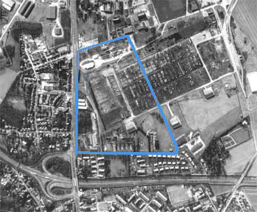
Size of competition site: 8.5 ha
Number of inhabitants: 256,000
Agglomeration
As the third largest city in the state of Bavaria, the regional center of Augsburg is the historical, cultural and economic hub of the region with an economic area of 600,000 inhabitants. Founded 2000 years ago as a Roman camp, Augsburg experienced its heyday as a trading city during the Fugger period. The historical context is present everywhere in the many listed historic buildings. The good transport links by rail and road guarantee easy access to today's trade fair and university city of Augsburg, which has successfully practiced the transformation from textile industry to service city and environmental competence center. The combination of modern flair with the historic city center, the wide range of cultural facilities and attractive local recreation areas create a good quality of living.
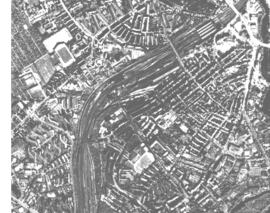
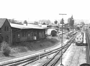
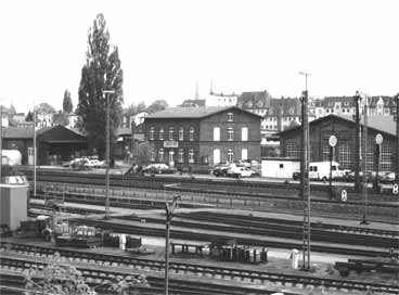
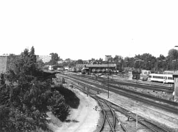
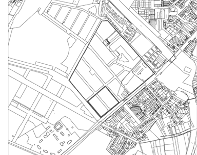
Location
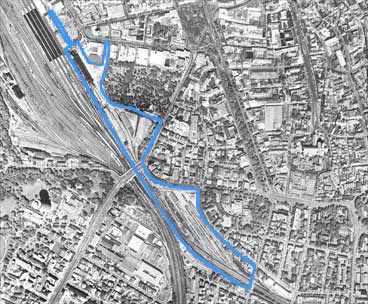
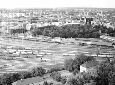
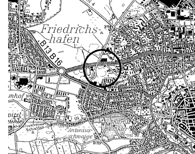
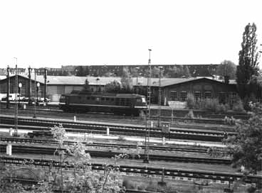
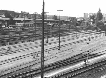
The abandoned loading yard freight terminal is located southeast of the main train station on the Ausgburg-Munich rail line. The vacated railroad wasteland is located in the western inner city area in the immediate vicinity of the pedestrian zone (3-5 minutes' walk) and has good urban and regional public transport connections due to its proximity to the main railway station and the central bus station. A core area and a cemetery border the area to the north, and a residential area from the Wilhelminian period to the east. The four-track Ausgburg-Munich railroad line forms the western boundary.
Objectives
The central location of the competition site offers good starting points for a graduated urban development close to the city center. The inner loading yard is to be developed as a core area, the middle loading yard as a mixed area and the outer loading yard as a residential and mixed area. Function and design are to fit into the surrounding area. At the same time, a city skyline is to be created as an entrance situation for rail passengers. An important component of the planning is a connection from the Gögginger Bridge to the main train station, which is to open up the area at the same time.
Program
The aim of the planning is to activate and revitalize the area. A functionally mixed quarter with areas for services, administration, city logistics and individual living is to be created, which promises dynamic development thanks to its excellent public transport connections to the city, the region and the state capital Munich. Due to the remaining railway tracks in the east, the noise protection problem is of particular importance.
Topic
The derelict railroad site offers areas for urban development close to the city center, which are to be revitalized by linking models to surrounding neighborhoods and lead to the emergence of a new urban quarter.
E6: Ingolstadt
Location brief description
Size of competition site: 0.6 ha
Number of inhabitants: 115,000
Size of area under consideration: 4 ha
Agglomeration
Ingolstadt is located in the geographical center of Bavaria and is a modern business city with a wide range of educational and training facilities. The refinery center and the automotive industry, but also a multi-layered structure of medium-sized businesses have made Ingolstadt one of the most important growth regions in Germany. The city on the Danube is the transportation hub of an economic region with over 400,000 inhabitants. Ingolstadt also has excellent supraregional connections via rail and the Munich-Nuremberg-Berlin and Frankfurt/Main freeways. The old town of Ingolstadt is characterized by an old town center that was built in the 13th century. In the course of the city expansion, differently structured districts with partly metropolitan, partly rural character have been created.
Location
The competition area is located northwest of the old town core and is divided into a northern and a southern area by Richard-Wagner-Strasse, a main traffic road. To the north of the street is a housing estate from the 1970s; to the south of the street, a new residential quarter in experimental housing construction has been under construction since the mid-1990s. The competition site comprises in the northern area the area of the five point houses, a garage yard, as well as the adjoining property to the east, which is used as a parking lot, and in the south the undeveloped property including the footpath.
Objective
The objective of the competition is to round out the new development area south of the street with innovative residential construction and at the same time to create a meaningful connection and link across the street with the residential development of the 1970s, which is to be upgraded through structural improvement measures. The improvement of the residential environment is to be achieved through attractive offers in the outdoor space, noise protection measures to the street and the introduction of additional functions through redensification.The public space is to be redefined through the redesign of the street spaces, improvement of the footpath network with the creation of crossing possibilities of Richard-Wagner-Strasse and the upgrading of the semi-public green spaces.
Program
On the southern site, a four-story residential building in social housing (at least 40 apartments) is to be developed. In the northern area, proposals are expected for upgrading the residential environment and improving the spatial structure, e.g. by demolishing garage buildings and redensifying with small-scale commercial units.
Subject
The competition area shows a heterogeneous development structure in the transition area between residential areas of different times. The area, which is additionally divided by the street, is to be revitalized by the new development of the southern plot, the creation of path connections and the addition of small-scale commercial functions.
E6: Lübeck
Location brief description
Population: 215,000
Scale of competition site: 10 ha
Agglomeration
The Hanseatic City of Lübeck in the federal state of Schleswig-Holstein is a regional center of supraregional importance. Its convenient location on the highway along the Baltic Sea coast and to Hamburg is a good prerequisite for economic development (growing Baltic Sea port). In addition, Lübeck has great cultural (Old Town as a World Heritage Site) and also tourist significance (Travemünde seaside resort) for the entire region. The city strives for a differentiated further development of structural densification and dynamic economic development.
Location
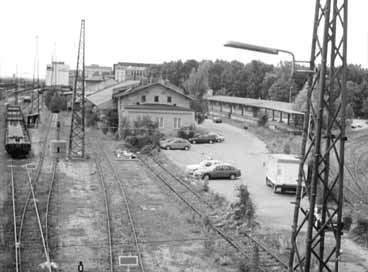
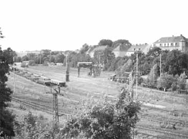
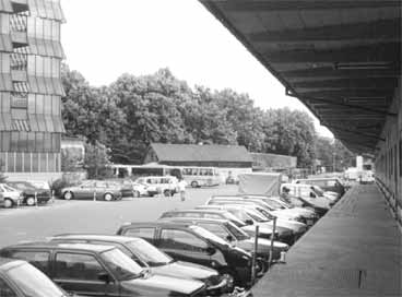
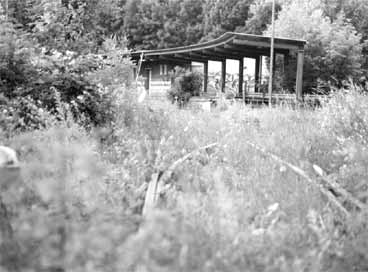
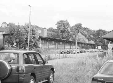
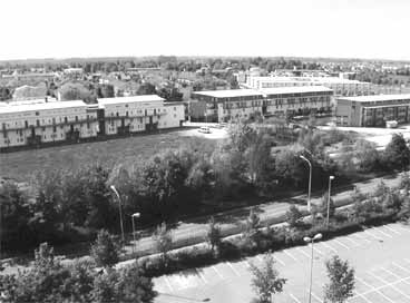
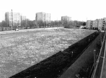
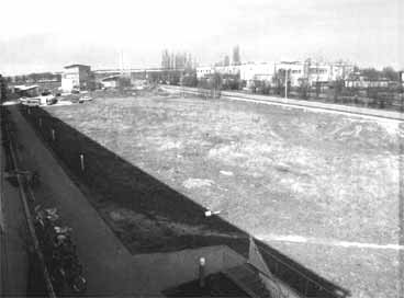
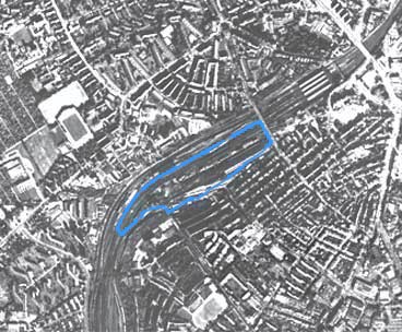
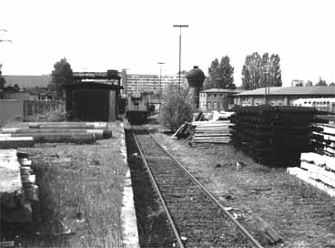
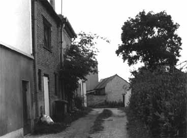
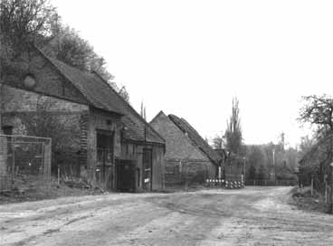
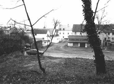
The area near Lübeck's main train station is located in an urban renewal area of the "Social City" urban development program and includes the areas of the former freight station. The competition area is located close to the old town between two urban renewal areas. The area to the south of the old town developed between 1850 and 1950, the residential and commercial development to the north of the railroad line in the 2nd half of the 20th century. The existing development consists of railroad service buildings, a large freight shed, and an old locomotive shed with water tower, as well as extensive unused trackage. The site can be accessed by delivery and individual traffic to a limited extent, and there are good public transport connections as well as footpath and cycle path links to the old town.
Objectives
The area offers large-scale development potential for a multifunctional quarter due to its proximity to the historic old town and the main railway station. However, the area is not to be developed as an isolated unit, but is to incorporate and further develop the structures of the adjacent buildings. Due to the only conditionally efficient development for individual traffic, a rather low density is planned despite the inner-city location. This allows for a special examination of the theme of city and nature. The identity of the place is to be guaranteed by partial preservation and conversion of existing buildings. Due to the remaining railroad area in the north, the noise protection problem is of particular importance.
Program
A socially mixed neighborhood with various uses is to be developed. In addition to areas for individual living and public open spaces, commercial, office and service, recreational and cultural facilities are also planned.
Topic
The derelict railroad area lies as an "in-between space" in need of a new identity, between urban expansions of different times. The site, which has been little used by the railroad to date, is to form another building block in the inner-city fabric through new types of uses. The size of the area offers the possibility to develop completely new morphologies.
E6: Mönchengladbach
Location brief description
Size of competition site: 3 ha
Number of inhabitants: 270,000
Agglomeration
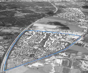
The city of Mönchengladbach, the largest city on the left bank of the Lower Rhine, is located in the west of the state of North Rhine-Westphalia and has a central function for the medium-sized centers located in the surrounding area. The service area comprises approx. 600,000 inhabitants. The city is a crossroads and mediator between the European growth poles on the Belgian-Dutch canal coast (Antwerp/Rotterdam) and the Rhine-Ruhr railroad (Cologne/Düsseldorf/Duisburg) and therefore has a high locational advantage. Since the mid-1990s, the conversion of properties formerly used by British armed forces has been a focal point of municipal urban development. In particular, the urban redevelopment of the North Park (former Ayrshire Barracks North) offers the city the opportunity to reintegrate into the urban fabric an area that had been removed from the city's planning jurisdiction for decades.
Location
The competition area comprises a partial area of the North Park site, which covers a total of approx. 160 hectares and for which an urban planning framework has been developed under the guiding principle of "Sport, Leisure, Culture". The area, which is located about 3 km from the city center, is well developed due to its proximity to the city airport (7 km) and its direct connection to the A 61 and the B 57. The building sites planned for short-term realization are located at the intersection of the existing B 57 (Gladbacher Straße) leading into the city area and the planned main access road for the new area.
Objective
The objective of the competition is to obtain concepts that can be realized in the short term on the basis of the planning to date and that define the urban planning and design qualities of this newly emerging quarter.The aim is to create a socially mixed quarter that offers leisure and recreational opportunities for various population groups in addition to living and working.A sustainable concept is desired that takes into account possibilities for the use of environmentally compatible building materials as well as the development of measures to reduce energy requirements and the reduction of existing traffic noise immission.
Program
The aim is to achieve a mixture of residential and work functions under the guiding principle of a "city of short distances". Densified multi-story residential construction in the form of a four- or five-story perimeter block development with noise protection function is to be provided for individual residential development of the inner block areas.
Subject
The development of the Nordpark site is intended to complement the existing settlement structures of the city of Mönchengladbach. The urban redevelopment of this area close to the city center offers the opportunity to develop a new quarter that will sustainably improve the city's economic structure by attracting promising companies from the sports, leisure and service sectors.
E6: Nauen
Location brief description
Size of competition site: 2.8 ha
Number of inhabitants: 11,000
Agglomeration
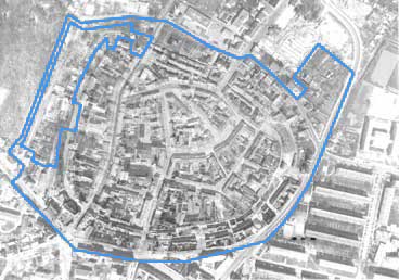
The city of Nauen is located in the federal state of Brandenburg in the northeastern part of the Havelland Fläming region, between an extensive landscape conservation area in the east and predominantly agriculturally used areas in the south.The federal highway 5 with freeway access and the railroad offer good connections to the federal capital Berlin, located about 25 km to the west, and the state capital Potsdam, located to the south. For the surrounding communities, Nauen has a central importance as a middle center. The city strives for a differentiated further development of the various functions of living, working, recreation and supply in the old town.
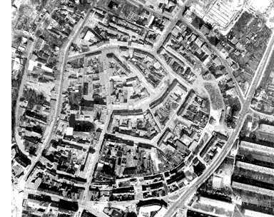
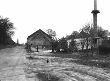
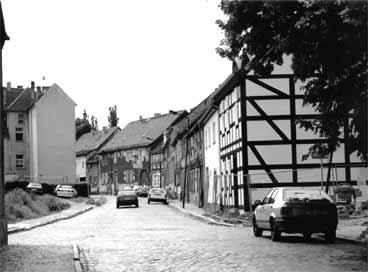
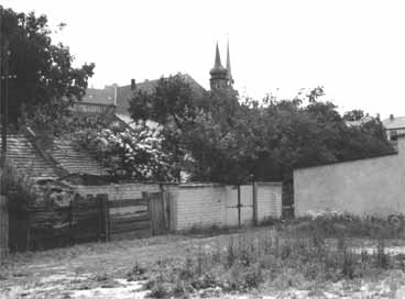
Location
The competition area is located within the redevelopment area on the edge of the old town and is bounded to the east by Mauerstrasse with its historic ring road and to the west by the town park with its open-air stage.The site is accessed via Parkstrasse to the north and Scheunenweg, which directly connects to Bundesstrasse 5 to the south.Despite its central location, the site has been characterized for decades by increasing vacancy, particularly of the historic barn buildings. Today, the area is characterized by fallow land and garden land.
Objectives
The area has good potential for the development of a contemporary quarter for housing and services due to its immediate proximity to the medieval city center. The development concept should take into account and further develop the existing historical elements. Particular importance is attached to the listed water tower and the historic barn buildings, which are to be included in the design and utilization concept.Sustainable building concepts are to be developed that incorporate ecological building materials and resource-saving techniques and that blend in carefully with the medieval town layout.
Program
A socially mixed neighborhood with different building typologies (duplexes/row houses, town houses, multi-story housing) is to be developed. Housing for household founders and older persons (1-2 person households) as well as families with 3 to 6 persons shall be offered. Particularly in the area of rental housing, areas for crafts and offices are to be provided.
Theme
The redesign of the competition area is intended to redefine this transitional area between the densely built, medieval old town and the area beyond the city wall, which is characterized by green spaces and open construction. The connection of the new quarter to the old town is to be strengthened in terms of urban development; at the same time, an interlocking with the adjacent open spaces is to be made possible.
E6: Taufkirchen
Location brief description
Size of competition site: 57 ha
Number of inhabitants: 18,000
Agglomeration
The municipality of Taufkirchen, located about 15 km south of the Bavarian state capital Munich, consists of two districts: a mature village structure east of the railroad line and the large housing estate "Taufkirchen am Wald" west of the railroad, which was built in the early 1970s. Taufkirchen is a sought-after residential location due to its immediate proximity and good transport links to the city of Munich, which is of supra-regional importance as an economic, commercial and cultural center with important educational and research facilities, and the attractive local recreation areas in the south of Munich.
Location
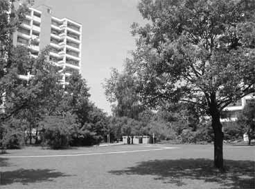
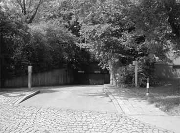
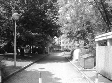
The competition site comprises the area of the large housing estate "Taufkirchen am Wald. In just a few years, a residential quarter for over 10,000 residents has been created, comprising 3,800 apartments as well as the necessary infrastructure facilities such as schools, kindergartens, denominational community centers and shopping centers. The area is bordered to the west by the autobahn with direct access and to the east by the S-Bahn line with the Taufkirchen stop.
Objectives
The objective of the competition is to develop visions of how a large housing estate from the 1970s can be further developed to meet the changing needs and demands of its residents in order to remain livable for the next decades.By introducing new functions, the long-term aim is to achieve a change from a purely residential town to a combination of living, working and leisure.The residential environment is to be strengthened by attractive outdoor offerings and differentiation into private, semi-public and public areas. The quality of the outdoor space can be redefined by reducing sealed surfaces and replacing above-ground parking spaces with underground garages.
Program
The task is to develop a conceptual idea for the entire area and its interconnection with the old and new town centers. Based on a residential quarter to be freely selected by the competition participants, proposals are expected that are suitable for making the quarter fit for the future. In addition to concrete proposals for moderate additions to the building structures, particular importance is to be attached to outdoor space planning.
Topic
"Taufkirchen am Wald" is exemplary for large housing estates of the post-war period, which were built in a very short time under great pressure of demand. Today, these areas are the focus of attention, not least because of their monofunctional structure. These settlements, which were built on greenfield sites at the time, are today often highly favorable in terms of location, embedded in the settlement network of urban expansions. By offering a differentiated range of housing types and adding new functions, the area is to be further developed to meet future needs.